onWater Fish - Fishing Spots
- 4.3
- Rating
- 100.00K
- Installs
- Free
- Price
 Analysis by App-foxy
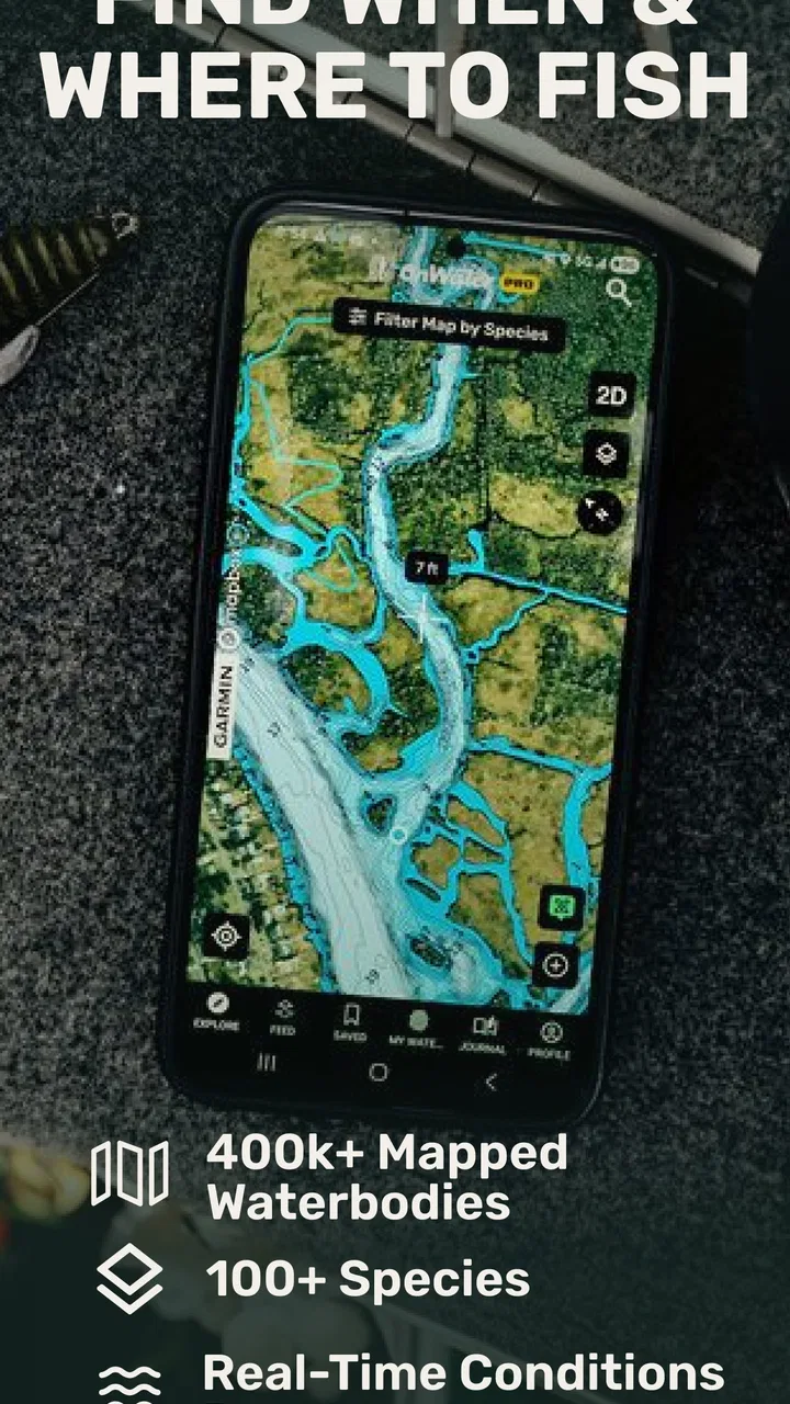
I spend enough time planning fishing trips to know that the difficult part is often not choosing a lure. It is deciding where to go, whether the water will be comfortable, how access might work, and whether the conditions are worth the drive. onWater Fish - Fishing Spots brings several of those decisions into one Maps & Navigation app, with fishing points, map layers, weather forecasts, property boundaries, and USGS streamflow information.
My first impression is that this is less of a “find a secret fishing hole” tool and more of a planning companion. That distinction matters. It can help me organize a trip around public information and map context, but it does not replace local knowledge, legal checks, or a careful look at the shoreline. For anglers who like to prepare before leaving home, that combination is genuinely useful.
How the app feels in its current form
The app is developed by onwater llc and is available free of charge, with optional in-app purchases ranging from $6.99 to $89.99 per item. Its store summary points to the main experience: fishing locations, mapping, weather, land boundaries, and streamflow readings. In practice, those elements make the most sense when used together rather than as isolated tools.
You May Also Like

 Blood Strike: 2.5 Anniversary
Blood Strike’s Loadouts Turn Every Drop Into a Tactical Gamble
A close look at Blood Strike’s custom loadouts: how fast access to signature weapons reshapes its battle royale rhythm, rewards preparation, and narrows the gap between fights.

 Pandora - Music & Podcasts
Pandora’s Music Is Easy to Start, but Harder to Recover
Pandora’s strength is its low-effort path from a seed to a station. Its weak spot is how much confidence it asks you to place in connection, setup, and quiet recovery.

 8 Ball Pool
 Is Built on Rivalries, Rematches, and Routine
A close look at the rivalries, rematches, shared routines, and unanswered safety questions that turn a quick pool match into a persistent mobile community.

 Samsung Music
’s Quiet Strength Is Playing What You Already Own
Its reach comes less from spectacle than from dependable access to a personal library. That simplicity is both the app’s strongest retention engine and its ceiling.

 AccuWeather: Weather Radar
AccuWeather Review: A Quick, Clear Forecast for Everyday Decisions
For everyday plans, the best forecast is the one you can understand quickly. AccuWeather makes rain timing, radar, and local conditions easy to act on, with a few trade-offs.

 Hill Climb Racing
Why Hill Climb Racing Still Turns Crashes Into One More Run
A tiny car, a bumpy hill and one more upgrade: Hill Climb Racing keeps resurfacing because its simple chaos makes every near-miss feel personal.
More From Our News Desk



I would open the map first, locate a lake, river, or nearby shoreline, and then use the surrounding information to decide whether the spot deserves further attention. A marker may start the process, but the boundary layer and conditions around it are what help turn a vague idea into a workable plan. That is a better workflow than searching randomly through ordinary map pins or relying only on a general weather app.
The app has a 4.3 average from around 983 ratings, with 186 written reviews, and it has passed 100K+ installs. Those figures suggest that it has found a real audience among people looking for a fishing-focused map rather than a general navigation service. I still would not treat popularity as proof that every location is equally complete. Fishing information can vary considerably from one area to another, and local conditions change faster than any map database.
It is rated for Everyone, which fits the straightforward nature of the product. The current version is 3.3.0, and the app requires iOS 11 or later. That makes it approachable for many phone users, although anyone with an older device should check compatibility before planning around it.
What I use before leaving home
My most useful routine is to begin with a broad area instead of immediately chasing a single point. I look for several possible places, compare their proximity to roads and water, and then inspect the nearby property boundaries. This changes the question from “Where is a fishing marker?” to “Can I reach this water legally and practically?” That is a small but important improvement over ordinary map browsing.
Weather information becomes more valuable at this stage. I am not using it as a guarantee that fish will cooperate; I am using it to judge whether the outing is comfortable and sensible. Wind direction, changing conditions, and the timing of a trip can affect whether a bank, boat launch, or exposed shoreline is worth visiting. The app’s weather context is most helpful as part of that decision rather than as a replacement for a dedicated forecast service.
Streamflow information is especially relevant for river anglers. A river can look familiar on a map while behaving very differently after rain or during a seasonal change. USGS streamflow readings give me a more grounded way to think about current conditions than simply looking at yesterday’s weather. I would still check the specific gauge and interpret it alongside local knowledge, but having flow information close to the fishing map can prevent a poorly timed trip.
A realistic weekend planning example
Imagine I have a free morning and want to fish a river within driving distance. I can use the map to identify several points, check whether the surrounding land appears publicly accessible, and compare weather conditions before choosing one. If the river has a USGS streamflow reference, I can consider whether the water level or current may make bank fishing uncomfortable or unsafe.
That process does not tell me which lure to tie on, and it cannot promise a catch. What it does is reduce wasted travel. I may discover that the closest point sits beside restricted property, while another location farther along the river offers a more realistic access plan. The app earns its place on my phone through that kind of practical filtering.
A second useful scenario is a spontaneous trip while traveling. Instead of opening a general map and searching for “fishing,” I can use a fishing-oriented view to build a shortlist. I would still verify local regulations, parking, boat access, and seasonal restrictions separately. The app helps with discovery and orientation; it should not be treated as the final authority on permission or safety.
What has changed and how that affects regular users
The current release is 3.3.0, while the app first appeared on August 25, 2021. That version history gives the product time to mature beyond a simple collection of fishing pins. The important evolution is not just the presence of more map content; it is the way different layers can support one decision. A point becomes more useful when I can view it alongside weather, boundaries, and water-flow context.
For a new user, this makes the learning curve manageable if the app is approached as a planning workspace. I would not try to understand every map element at once. I would begin with one familiar body of water, compare what the app shows with what I already know, and then expand to unfamiliar areas. That approach also helps reveal where the map is strong and where I need another source.
Existing users may appreciate the broader role the app plays in a trip. A fishing map alone is useful for discovery, but a map that encourages me to think about access and conditions is more valuable before departure. The trade-off is that a richer map can require more attention. I need to examine layers and context instead of tapping a marker and assuming the job is finished.
One advanced habit I recommend is using the app to create alternatives rather than a single destination. I would identify a primary location, a backup nearby, and another option in a different section of the water. If weather shifts or access looks questionable, I can adjust without beginning the search again. This is a more reliable workflow than treating the first attractive point as the only plan.
Another non-obvious strength is the way property boundaries can change the meaning of a fishing spot. A point near water may look promising, yet the practical access route could cross private land. Studying boundaries before driving saves time and helps avoid an uncomfortable conversation at the shoreline. It also encourages better fishing etiquette: the presence of a marker is not the same thing as permission to enter.
Streamflow adds a similar layer of judgment. I would not compare a reading from one river with a reading from another as if they were interchangeable. Instead, I use it to watch for meaningful changes on the water I intend to fish. A familiar access point may be fine at one flow and poor at another. That makes the feature particularly useful for river planning, but less central for someone who fishes only small ponds or stocked lakes.
Where the app still needs a careful approach
The biggest limitation is that no map can fully describe a fishing location. Shoreline conditions, vegetation, parking, construction, seasonal closures, and actual fish activity may all differ from what appears on screen. I would never use a marker as proof that a place is open, safe, or productive. Before going, I would confirm local rules and access details through the relevant authority or land manager.
There is also a difference between finding water and navigating to a precise fishing position. A general navigation app may still be better for turn-by-turn driving, road closures, and detailed address handling. I see onWater Fish as the specialist layer that helps choose and evaluate a destination, while a conventional navigation tool may handle the final road journey more effectively.
The free entry point is welcome, but the in-app purchase range means I would pay attention to which tools are included and which require an upgrade before building my routine around them. The app is easiest to recommend to someone willing to explore its free experience first, then decide whether the additional functions justify spending more. I would not assume that every angler needs the highest-priced option.
Another limitation is relevance. If I mostly fish from a boat with a separate charting system, or if I already have detailed local maps and a trusted weather workflow, this app may add less value. It is strongest for people who want fishing-oriented discovery and planning in one place. It is not automatically the best replacement for specialized marine navigation, official regulations, or a local fishing report.
Practical ways to get better results
I recommend checking a location at two different moments: once while planning and again shortly before leaving. Weather and flow context can change, and a route that looked sensible earlier may no longer fit the conditions. This simple repeat check is more useful than saving a point and never revisiting it.
I would also separate three questions in my notes: can I reach the water, am I allowed to fish there, and are the conditions suitable today? The app can contribute strongly to the first and third questions, and its boundary information can alert me to the second. None of those questions should be collapsed into one assumption. That distinction is one of the most important lessons for new users.
For unfamiliar rivers, I would use streamflow as a comparison tool over time rather than obsessing over one isolated reading. A rising or changing pattern may matter more than a number viewed without context. I would pair that observation with the forecast and the actual access point. This workflow makes the feature more meaningful than simply opening a gauge because it is available.
For family outings, the Everyone rating and map-based design make the app approachable, but I would still plan conservatively. A map can identify water and nearby points, yet it does not remove hazards around currents, slippery banks, heat, or changing weather. I would choose an accessible location and treat the app as preparation, not supervision or safety equipment.
Who should use it, and who should skip it
I think the app is a good fit for anglers who regularly explore unfamiliar waters, bank fishers who need to think about land access, and travelers who want fishing-specific map context. It is also useful for someone who currently jumps between a general map, a weather app, and a water-level website. Bringing those planning questions closer together can make a short fishing trip feel much less improvised.
I would be more cautious recommending it to a person who expects exact catch predictions, complete local regulations, or guaranteed access details. Those expectations are too high for any mapping app. It may also be unnecessary for an angler who fishes one private pond and already knows every route, boundary, and seasonal pattern.
Boat anglers should consider what their existing electronics already provide. If a dedicated system offers the depth charts, navigation accuracy, and water-specific tools they need, this app may work better as a scouting aid than as the main navigation solution. Shore anglers and explorers are more likely to notice its central benefit because the relationship between a map point, land ownership, weather, and river conditions directly affects where they can stand and fish.
What I would watch in future updates
As the product continues to evolve, I would pay attention to how consistently the map information reflects real-world access and changing conditions. Better freshness and clearer context would matter more to me than simply adding more markers. The most valuable direction would be helping users understand whether a point is practical today, not merely showing that it exists.
I would also watch how the paid features fit into everyday planning. The free version gives people a chance to judge the map’s usefulness in their own area, while optional purchases create room for more advanced workflows. The best balance would let occasional anglers plan a simple outing without friction while giving frequent explorers a clear reason to upgrade.
For now, I see onWater Fish as a focused planning tool rather than an all-purpose fishing authority. Its combination of fishing points, weather, boundaries, and USGS streamflow gives it a distinct role, especially when I am considering unfamiliar water. Its real strength is helping me reject bad plans before I leave home.
I would recommend trying it if your fishing decisions often begin with “Where can I realistically go?” rather than only “Where are the fish?” Start with a nearby location you already understand, test the map against your experience, and then use it for a new trip. That approach gives the app a fair evaluation and keeps its limits clear. It is free to start, suitable for Everyone, and useful enough to earn a place in my pre-trip routine, provided I continue to verify regulations, access, and safety through the proper local sources.
FAQs for onWater Fish - Fishing Spots
01What is onWater Fish - Fishing Spots?
onWater Fish - Fishing Spots is a fishing navigation and discovery app designed to help anglers find productive waters, identify access points, and explore fishing locations. It combines map-based information with details about lakes, rivers, ponds, and coastal areas, making it useful for planning trips, checking unfamiliar locations, and organizing fishing adventures before leaving home.
02Can onWater Fish help me find fishing spots near my location?
Yes. The app is built around an interactive map that lets you browse nearby lakes, rivers, ponds, and other waterways. Depending on the location and available coverage, you may be able to view fishing access information, waterway details, and nearby points of interest. Location permissions are generally needed for the most convenient nearby-spot experience.
03Does onWater Fish provide information about fish species and fishing conditions?
The app can provide useful waterway and fishing-related information, but the amount of detail may vary significantly by region. Some locations include species information, access details, or other angler-focused data, while less-covered areas may show only basic map information. You should treat the app as a planning aid and verify local regulations, seasons, and conditions independently.
04Is onWater Fish free to download and use?
onWater Fish may be available to download at no initial cost, but some features, map layers, or premium tools can require a subscription or in-app purchase. Pricing and included features may change over time and can differ between Android and iOS. Before downloading or starting a trial, review the current store listing and subscription terms carefully.
05Does onWater Fish work without an internet connection?
Offline availability depends on the specific version of the app and the features included with your account. You should not assume that every map, fishing spot, or detail will remain accessible without mobile data. If you plan to fish in a remote area, open the required maps beforehand, check whether offline downloads are supported, and keep a backup navigation method available.
Pros
- Detailed fishing spot information helps plan trips more efficiently.
- Useful for discovering unfamiliar waters and nearby fishing locations.
- Weather and water details can support better timing decisions.
- Community-sourced reports add practical local insight.
- Clean map-based browsing makes spots easy to compare.
Cons
- Coverage and report quality may vary significantly by region.
- Some useful features or data may require a paid subscription.
- User-submitted information can become outdated over time.
- Location accuracy may depend on GPS and available map data.
- Frequent use outdoors can consume battery and mobile data.

onWater Fish - Fishing Spots
Gallery